Charleston

Because I had gone to bed so early, I was able to wake up around 6am. That’s early for me. The rays of the sun were beginning to sneak over the horizon as I ate breakfast, took down my tent, and packed my bags. I was off at about 7:20, a little later than I wanted, but still a really good start for me.

The first eight miles were not too bad. I don’t like backtracking, so I wasn’t too excited about re-doing the mileage I had just done the day before. I had to remind myself that free camping was a pretty good price, and this would probably be as scenic as it got for the day. After this little highway, I was back on 17 until Charleston. After about forty minutes, I reached the junction with the hardware store, the yellow caution light, and the gas station. I refilled my water bottles in the bathroom, and then did some stretching.

2 miles down the road, I reached for my water bottle and discovered it was missing. I must have left it at the gas station. Four miles to go back and get it. Twenty minutes of the day lost. Cost of the water bottle was about five bucks. I did some cost/benefit analysis in my head. I really didn’t have anything else to do that day. I really wanted to see a bit of Charleston though. My income stream right now is zero though, so putting my time value at fifteen dollars an hour seemed rather high. I turned back and got the water bottle. The whole rest of the day though, I just kept thinking about the twelve miles of backtracking I had done. Essentially an hour’s worth of unnecessary riding.

About ten miles away from Charleston, I saw a sign advertising a Gullah restaurant with a buffet that would be seven miles ahead in Mt. Pleasant. Gullah, made famous by the TV show, is an interesting culture that has survived on the islands in the Southeast. I had never had Gullah food before, but I imagined it would be delicious. I made a mental note that I should look for that seven miles ahead. Seven miles later, I found it. The food was more or less soul food, so not much new in terms of “Gullah.” It was delicious though. I had two full plates and some banana pudding. I then got back on my bike with about twelve miles to go. All I really wanted to do after eating so much food was close my eyes and take a nap. That’s the problem with buffets for lunch.

Back on the road, I was only a couple miles from the gigantic Ravenall Bridge that connects Mt. Pleasant to Charleston. Fortunately, it was built with an awesome pedestrian/bike path going over it, so it was not too difficult to cross. It was quite a climb on my bike, but it felt good. I was missing hills (crazy, I know), and I just wanted something other than flat and boring 17. Crossing the bridge spit me right out in downtown Charleston. I was tempted to just ride around and see the city, but I wanted to store my bike away for the evening.

I pushed ahead and crossed bridge number two: The James Island Connector. This bridge did not have a pedestrian/bike path. It did have large shoulders though. My friends had said that switching to the left-hand shoulder could be good because the right-hand side has a few exits and cars have to leave and get on the highway. I considered this, but I decided to stick with the right-hand side. I’m used to dealing with cars to the left of me, and I thought having them on the right would just freak me out. Plus with my awesome helmet mirror, I can usually navigate the exit ramps pretty well.

I reached my house for the night and took a much needed shower. Then I bought a new tube (to replace the one I had used for the flat leaving Myrtle Beach). Finally, I went out to the bus stop. There was a bus that would take me right downtown. I could bike back over bridge number two, but I really didn’t feel like doing eight more miles that day over bridges and then having to leave downtown before the sunset. Public transportation was clearly the way to go. I had no idea what the bus schedule was, but I was optimistic. Surely, it wouldn’t be too long. Ha. I was no longer in the Northeast Corridor that has somewhat functioning public transportation. I was in the South. The next bus wasn’t coming for an hour. I read the local alternative newspaper, saw that there had been a Pixies concert there the previous week and in a couple days there would be a large Civil War re-enactment. Charleston sounded amazing.

Bus finally comes and I meet a young woman named Amy who works at Chick-fil-a. I needed to know the schedule of the bus, but it wasn’t posted anywhere on the bus. Fortunately, she had a schedule on her. We started talking, and I said I was a tourist. She was going to the visitor center to buy some bus passes, and I figured that would be a good place for me to get a map, so we walked over there together. She offered to walk around the city with me, but my first task was to get some free wifi so I could map out my route home. She said she knew that the Medical University had free wifi, so she showed me where that was. She departed, and then I spent way too much time searching for a road from Charleston to Savannah. Of course, the road was obvious, it was 17. And the advice online was equally simple: DON’T DO IT!

Forum after forum said the road is dangerous and narrow. Traffic is heavy. Multiple people have died. It’s just not worth it. Great, I thought, 17 is a horrible road in the first place, and it is only going to get worse. (This turned out not to be true. The road was fine. But that’s another blog update.) I tried to find alternative roads. I looked to see how far out of the way I could go. Nope. It was all pretty much the same road ahead. I wrote down my directions and looked at my watch. It was already 5:00, so it was getting dark soon. I didn’t have too much time to walk around. I set off looking for two things: an ATM and a place to sit and have a beer. Charleston is pretty awesome because within two blocks, I had an ATM. And a block later, I found a beer bar that had flights of local beers. Awesome.

I ended up not even having to take the bus back across because my friend Amy (not Amy from the bus, but Amy from UGA) works downtown, so she was able to give me a ride. We met up with her husband Matt and we went to this awesome place for dinner. On their recommendation, I ordered the beer can chicken, and it was delicious. I didn’t know how I was going to eat after that Gullah buffet, but there was no way I wasn’t finishing the food. The place also had a great beer selection, and I did another flight of beers. It was a good day for beer tasting.

After dinner, I went back and just prepared a little for the ride the next day. I was so close to Savannah. But I had a dangerous road ahead. And still one more day in Beaufort. I couldn’t skip over Beaufort (well I could if I wanted to do 40 extra miles the next day, but I really didn’t want to do that). One day at a time. Charleston had been great. Then Beaufort. Then… Nope, let’s focus on Beaufort.

Day one on Highway 17 (into the forest!)

There’s no traffic on 17. Those were the words of my host Kyle the night before I departed from Myrtle Beach. I don’t know if he was trying to be macho in front of his girlfriend, but I would have to disagree with him. Up until that point I had ridden on roads from Boston to South Carolina. Yes, there were roads with more traffic, but those roads usually had a shoulder. Highway 17 had a sorry excuse for a shoulder mostly due to a rumble strip that took up most of it. Riding on a rumble strip is nearly impossible, so essentially, it had no shoulder.

Highway 17 was also the only way south unless I wanted to go miles out of my way. I was not excited about biking the next three days. The only thing that keeps me sane sometimes is keeping track of the directions. Okay, 5 more miles. Okay, 3 more miles. Once I left Myrtle Beach, I had two full days on Highway 17, and there is essentially nothing on it. Yeah, even Route 1 at least takes you through small towns every ten miles or so. On Highway 17, there is nothing. Nothing. Except traffic.

A few miles down the road from my host’s house, I started getting hungry. He had recommended that I check out a nice breakfast place on the way out of town, so I stopped in at the Spring House. Nothing special. Just your typical American breakfast of pancakes, sausage, and eggs. It was exactly what I was craving and carbed me up for quite some miles.

After that, it was back on the road again. South. Into the national forest. That night was the first night I planned on camping. 24 days or so and not once did I need the tent, sleeping pad, or sleeping bag that I had been hauling on my bike from Boston. I had bought a new tent just for this trip (although it’s more a life purchase, since I now have a tent). The story of my sleeping pad is that I bring it everywhere, and I hardly ever get a chance to use it. I don’t know why I imagined this trip would be any different. Anyway, I was going to camp, and that made me excited.

It was also going to be my first night to myself in over a month. Couchsurfing is amazing. I wouldn’t change a thing about the trip I had, but every night you have to be extroverted. Every night, you are meeting new people, and you only have one night with them. You want to be fun. You want to be interesting. Of course, you could just hole away by yourself and read or write or sleep, but it seems rude. And it’s not even that sometimes. The people you meet are often so interesting, you want to hang out and talk with them. So, I was peopled out by the time I got to the end of my trip, and I was looking forward to a night alone in the woods.

Charleston was about 90 miles from Myrtle Beach, a long day that I did not want to do. Fortunately, Francis Marion National Forest* was only 60 miles away. It seemed like a great stop. I’d be able to get to Charleston rather early in the day so I could explore this great city. Plus, camping in national forests should be free. You just need to check with the rangers first. So I called up the rangers to ask about camping and found out you need a camping pass to do wild camping. I could camp in a campsite that was about 6 miles out of my way (turned out it was 8 miles). Well, can I get a camping permit to camp anywhere? Yes, you can come by the office and get one. But I’m on a bike, so that wouldn’t really work. Can we do it over the internet, maybe through email? No, only through the mail or in person. It is 2011, National Forest Service. Please, make this process available over the internet.

The directions to the camp site were as follows. In McClellanville, you’ll see a caution light. Take a right there. It’ll be near Bill’s Auto Repair. That’s highway 57. Go down that road six miles and you’ll see the campsite. Not even a red light for McClellanville. Just a caution light.

Eventually, the traffic on 17 died down some once I was far enough away from Myrtle Beach. The shoulder eventually widened more. The wind also increased though. And the scenery never changed. It was a long day. I stopped at the dollar general to get some dinner. Peanuts, poptarts, and some ice cream for dessert. I thought the ice cream might melt before I reach the campsite, but I wanted to give it a try. I got to McClellanville and saw the caution light. And sure enough, the auto repair place was across the street. (Oh, I also forgot I had a flat tire leaving Myrtle Beach. That’s how professionally I handled this road flat. It was no biggie. Stopped, changed it, kept going. It was almost like an afterthought.)

I went six, then seven, and finally eight miles down the road before finding the camp site. It wasn’t a primitive site. It was mostly for RV’s. There were four or five of them parked around a central area, although each site had quite a bit of space on its own. I tried to use the water pump, but it was not working. Some nice RV owner gave me some water in a ziplock bag which was going to be my shower. I set up my tent, ate my pop tarts, built a small fire, watched the fire go out in ten minutes, then went to sleep at about 8:00. It was dark, and there wasn’t much to really do. I was all alone. And I loved it.

*In the original posting, I had typed Shawn Marion National Forest. My friend Ken Balla pointed out that this was a basketball player. A quick google map search showed the national forest is Francis Marion, not Shawn Marion. Francis Marion was a soldier in he Revolutionary War, perhaps better known by his nickname, the Swamp Fox.

Stats!

I love stats. Here is a statistical breakdown of my trip. Unless noted, these exclude my rest days.

Average miles per day: 55.6.
Median miles per day 59.5
Standard deviation: 16.4

Average miles per hour: 11.37
Median miles per hour 11.4
Standard deviation: 0.9

Average time on a bike: 5:14
Median time on a bike: 5:45

Days I did not bike: 6
Days I biked: 23
Days I biked over 50 miles: 15 (65%)
Days I biked over 60 miles: 11 (48%)
Days I biked over 70 miles: 5 (22%)

Longest day: 80 miles to Myrtle Beach
Most time on the saddle: 6 hours, 33 minutes
Fastest day: 12.5 mph, to Fayetville, to Myrtle Beach
Slowest day: 8.4 mph, to NYC (I got lost a lot)

Before the trip started, I thought I would be doing about 50 miles a day. I was saying that I would be doing 50 to 60 miles. In reality, my average was 55 miles and the median was 59 miles. I was actually biking much closer to 60 miles a day. I actually biked over 60 miles a day almost half of my riding days, and I broke 70 miles (which I considered a long day) 20% of the time. In other words, I was biking more than I expected to be. This was mostly due to having to bike to cities in order to find couchsurfers and getting lost for about 4 miles a day on average.

My average speed for the trip was 11.4 mph. This is on par with a lot of other touring cyclists. I know some touring people go much faster, but I have never actually been fast on my bike. I was getting faster on the second half of my trip as my legs grew stronger and the roads grew flatter. The last week also had a lot of wind, but somehow I increased my average speed despite the wind.

The time in the saddle does not really reflect the amount of time I spent “biking.” Generally, I would leave at about 8am and arrive between 2pm and 4pm. I was biking for about 8 hours a day, but I only spent about 70% of this time in the saddle. I would stretch a lot, take breaks for eating, or just walk around and take pictures. Often, I was just bored and really needed to stop just to break up the monotony. I would tell myself, okay, in one mile, you can pull over and stretch. Then after a mile, I would see a sign about half a mile ahead, so I would say, well, why don’t you just go that extra half mile, then stop by the sign. I would try to push myself as far as I could between stops, but I really did stop a lot.


Photos from the Carolinas

Photos from the final two states before Georgia. Lots of cotton, marsh, and smiling faces.

Facebook album with North Carolina and South Carolina Pictures

Raleigh to Myrtle Beach: Free rides, wind, and more of the Ravens

I cheated again going from Raleigh to Fayetville. Well, I thought I was going to Fayetville. It turns out my friend Joseph lives in a town about 20 miles above Fayeteville. Anyway, my Raleigh friend Andrew was driving to Charleston for the weekend the same day I happened to be departing Raleigh. I could have gotten a ride the whole way down to the coast, but that would be too much cheating. Instead, I got off at some random exit in the middle of North Carolina. I was happy to turn my Raleigh to Fayetville-ish day from a 50 mile day into a 22 mile day.

But it was a tough 22 miles. We departed Raleigh at like 1:30 PM. I finally got on my bike at about 2:15 or so. I knew I only had 22 miles to do, but I still felt like I was in a time crunch. I was also on the most random country roads one could imagine. From the interstate to my friend’s house, I think I took one road with a number on it. All the other ones were named after things like churches and had approximately zero cars. If I had somehow fallen off my bike and severely injured myself, I suspected it would be days before any car drove by that would find me. It was also really strange staring so late in the day. I was so used to the routine. I get in the road around 8am everyday. Starting at 2PM just confused my mind and my body.

Plus, there was wind. I somehow made it 2/3 of the way through my trip without heavy wind. The ride to Fayetville had wind. It was just annoying. I knew my pedal strokes should be putting me at about 14MPH, but I was only going 11 MPH. Speed doesn’t really matter on a tour, but it was just frustrating to feel that my energy was being wasted. And my muscles tired out a lot sooner.

Eventually, I made it to Joseph’s house. We had a good night that was pretty low-key. We did go to a nice restaurant bar where I wowed the crowd with my karaoke rendition of “Twist and Shout.” Really, if you’ve never performed that one, you should try it out. Lots of energy. A real crowdpleaser. I brought the house down. It was the first time I’d been at karaoke since I’d been back, so it felt good to get back in front of a crowd.

The next morning I left on time and headed south. My destination was the town of Lumberton about 55 miles away. Leaving Joseph’s house, I headed toward Fayetville along Ft. Bragg Rd/Ave/Blvd (I don’t remember). It was populated mostly be pawn shops and used car lots, although I turned off it before it got to most of the strip clubs (I passed only two). I got lost near the mall because there was an unmarked road. Eventually, I found the way though and rewarded myself with some Burger King soft serve. Really, I’ve eaten way too much fast food during this trip. Plus, I see all these signs advertising that something is “new,” and I have to try it. Turns out, BK soft serve is just like every other place’s soft serve.

I was on some back roads for about fifteen miles, but I was worried I’d get lost again. I found a numbered state road, and I decided to just take that to another numbered road that would take me all the way to Lumberton. It took some of the fun out of the ride (wondering if Google was going to get me lost somewhere), but I was not looking for more adventure. I was just looking to make it to Lumberton. The wind was back. It wasn’t as bad as the previous day, but I could still feel its presence. I just wanted to end my ride as soon as I could.

The family I stayed with in Lumberton was awesome. The official couchsufer was Sara, but she was gone with her husband most of the night at a friend’s house for dinner. Really, her mother took care of me. I ate a terrific dinner and drink some great sweet tea. We watched Harry Potter together before I took over their den so I could sleep. I couldn’t have asked for nicer hosts. That night, I went to bed early in preparation for the next day.

The ride to Myrtle Beach was going to be long. Google Maps put it at exactly 80 miles. I decided to set off extra early at about 730am. I wanted to get on the road before the wind really kicked up. It worked. The first three hours or so of my ride were amazing. I have decided that I actually like Sunday morning rides. There is no one out on the roads. Really, once I left Lumberton, I don’t think I saw a car for an hour. It was just me, the road, and the surroundings around me. The beauty of that ride almost made up for NC’s then-so-far lack of anything worth looking at.

The day didn’t last that way though. Eventually, I crossed in South Carolina, and then I neared Myrtle Beach. There seems to be no good way to approach Myrtle Beach. Unlike many of the closely-located cities of New England, southern cities are far apart from one another. There is less of a grid to choose from. Approximately fifteen miles away from Myrtle Beach was a looping highway that connected the major communities along the coast. I took the road that intersected this arc and headed toward MB. This road was not fun. It was not scenic. It had way more traffic than that rest of the day, and at times, it was horribly narrow with no shoulder. I could not wait until I finished the ride.

I made it into my couchsurfer’s apartment complex at right about 79.1 miles. This was not acceptable. I had to do 80. Heck, if I had two more hours of daylight, I might have pushed for 100 miles. Anyway, I left the complex and biked for another miles. 80 miles. Done. New personal record that sounds pretty impressive to most non-cyclists.

I met my couchsurfer, and after I got cleaned up, we went to a Maryland Crab House a few miles from his house. For whatever reason, there were a ton of Baltimore Ravens fans there. The place was packed, and everyone was wearing purple and black. We ate some overpriced seafood and watched the Ravens play horribly against some team. I forget now. Once the game was over, we were still sitting and talking, but the places completely emptied out. If they only do business for four hours a week, sixteen weeks a year, I can’t really imagine how they stayed in business. It was fun to watch football with passionate fans though, and the unexpected motif of Baltimore Ravens games continued for a third week.

I’m home!

So I know that according to my blog, I am still in Raleigh, NC. It has been a little harder to keep up with writing than I expected. However, I wanted to say that yesterday I rode into Savannah and got home at about 3:30. The next week will be full of friends, football, and Thanksgiving, but eventually I will end up blogging about Raleigh to Savannah. For now, here are some Savannah pics.

Across Virginia

Virginia was an amazing state to ride my bike through. Almost from the moment I left the DC metro area, I felt good about Virginia. The North had seemed crowded and compact. Even the places between cities in states like Connecticut had seemed small. Virginia seemed big and open. Between the forests, there were fields and beyond the fields and forests there were mountains. I was hitting this state at just the right time to witness the fall beauty, and the contrast of the colorful leaves on the bright blue sky behind them was breathtaking.

My first stop out of DC was the town of Culpeper, VA. There I stayed with my Nancy and her son. Surprisingly, it was Nancy and not her son that was on couchsurfing. I would say about 90% of the site is the expected demographic: young, unmarried people who aren’t quite settled down yet. However, there is a good mix on non-traditional hosts as well. Nancy and her son were great. I ate a good meal, had a good fold-out bed, and even better company.

When I was planning my route for the next day, I noticed it would be a short ride at less than 60 miles. However, Nancy recommended a 10-mile detour to the West. It would take me through some scenic countryside that was well-known among the local cyclist community. In fact, there had just been a big ride the previous weekend. I took her up on this, and I was not disappointed. It was amazingly beautiful as I headed toward the blue ridge mountains and surprisingly flat since the road took a path through a valley. There were certainly hills, but my body has gotten used to them by now, and this path managed to avoid the worst of them.


I rolled into Charlottesville while my host was still at work. He told me where the key was, and I let myself into his place. It felt a little weird coming home without him there. It was the right address and everything matched what he said it would, but I still had to wonder if I was in the right home. I just imagined a startled occupant coming home and wondering who this guy was taking a nap on their couch. Fortunately, it was the right house, and Chris came home a couple hours later.

Oh also, in Charlottesville, I stopped at the market to get some food and drinks. While I was there, a young woman came up and said her sister thought I had a nice butt. Not knowing how to respond, it said it was due to the padding in the bike shorts.

Charlottesville was a great evening. Chris invited some of his friends over and a couchsurfer who was new to the area. We had delicious plov and great conversation. I mentioned that I still didn’t have housing for the next day. I had emailed some hosts in Farmville later than I wanted to, and I hadn’t heard back yet. Ashley, who was new to Charlottesville, said that I should head to Lynchburg instead. She had friends there she was sure I could stay with. I looked at the map. It was about twelve more miles to Lynchburg than Farmville, and a little the west of where I wanted to go. Doable, for sure, but I wasn’t persuaded. I had already added ten miles to the route that day, and I wasn’t excited about going out of my way. Do you like saunas, she asked. Saunas? I LOVE saunas. It’s one thing I miss about the KZ. Yeah, my friends have a sauna, she said. You could use it. So I decided I was going to Lynchburg. It turned out that two of her friends were out of town and one was working but eventually she found a friend of a friend who would take me to the sauna and had a TV so I could watch the football game (LSU v Alabama).

After dinner, Chris and I rode around town a little bit on our bicycles. Charlottesville was hilly, but the hills were much more manageable without my 25 pounds of gear. The bike has a whole different feel to it when it’s not loaded down. We checked out a new bar downtown, saw UVA’s campus, and then just went back to his place. It was a good Friday night.

The next day I woke up and set off for Lynchburg. There was one highway that was pretty much a straight shot, but I had heard that it was pretty busy. I wanted to avoid that for a few miles, so I took a couple smaller roads out of town. This was awesome and horrible.  Lynchburg was supposed to be a 72 mile ride, and I don’t like to do that long in one day. I knew my legs were going to be tired by the end. So when the scenic route decided to go up a mountain, I was wondering if I’d made the right choice. I mean, it wasn’t a real mountain, but I did climb for about an hour. There were some downhill breaks, but overall, it was up up up. It was gorgeous, of course, but my legs were feeling it. Finally, I crested and felt the roads generally sloping downward. Google directions had me turning left down another road, but when I came to this road, it looked less than favorable. It was gravel and dirt and seemed to head off to nowhere. The names checked out though, so I just went with it. Three miles of bumpy riding finally took me out the highway. I was on my way again.

The rest of the ride was good. Major highways are generally flatter than back roads, although the traffic was pretty heavy at times. I rolled into Lynchburg about an hour before sunset and found my host’s house. Dusty was a great guy. He wasn’t even on couchsurfing; he was just a friend of a friend.  He was excited to be hosting though, and we talked a lot about our international travels. We made dinner, watched some TV, and then we hit up the sauna at his friend’s house.

The sauna was in the basement of his friends’ house. The house was owned by a Finnish couple who had installed the sauna shortly after buying the house. They didn’t live in the house anymore, but they rented it to friends. The sauna was a popular feature. It was nice. Wooden benches, wooden walls, a simple switch to turn it on and off. I kinda missed the burning wood though of a Kazakhstan sauna. They also didn’t have any tree branches to hit one another with. In addition to me and Dusty, there were about five others guys that were sauna-ing as well. It was a popular thing to do with their group of friends. I must admit, I did not put up my best performance. I was tired and couldn’t stay in for very long. It felt good to be in there and sweat though, and I think it helped with my sore legs as well.

After about an hour, we left the sauna and went back to Dusty’s. I was exhausted. It had been a long ride. It had been a sweaty evening. It was time for bed.

The next day my ride supposed to only be about 60 miles. I was headed to Halifax, VA. I left Lynchburg with ease and was following my directions. I got off of Highway 29 and onto some country roads to cut through to Highway 501. Everything seemed to be on track when I came to a highway. My directions indicated this should be 501, but there were no signs. I was supposed to take a right, it seemed like that direction would be north. (My inner compass has been improving with this trip.) I saw a gas station about 400 meters up the road, so I went there and asked a nice couple pumping gas for directions. Is this 501, I asked. No, this is 29, the said. 29! I had just gotten off 29 twelve miles back. They had a map though, and we figured out how I could cut back across to 501.

I must have written the directions down wrong on the country roads. One ironic thing was that as I was on the country roads, I came to a junction with a state highway. When I was starting my trip, I would always get out my map at these junctions to see how far I’d gone. It also made sure that I was still on track. That day, I was thinking about how much time I must be saving by not having a Virginia map because I wasn’t constantly stopping to see my progress. However, had I had a map to look at, I would have realized the directions I had were probably not correct.

Overall, my wrong turn cost me about 14 miles, and just over an hour of cycling time. It was scenic, but it was scenic scenery I’d already seen for hundreds of miles in Virginia. Fortunately, all of Sunday was much flatter than the previous days. I was headed away from the mountains of Virginia as I approached the North Carolina border.

Eventually, I got to 501, and I took that all the way down to Halifax. There wasn’t much of note on the road. I passed through a number of small towns. I stopped at a nice local fast food place and got a milk shake. Overall, the road was not that busy, but it didn’t have much of a shoulder. Mostly, I was just bored. Flat, unchanging scenery, 14 mile detour. That’s what I was thinking about. Once I arrived in Halifax, I assumed I was almost there. I didn’t write down mileage indicators that day, and I saw I only had two turns left. I couldn’t find the road I was looking for though, so I called my hosts. Oh, you’re on that road. Good! You are only about three miles away! Three miles! I thought I was half a mile away. I had the right directions, but I just didn’t realize I was going to be going miles down the roads I had left.

I reached the house of Kevin and Amanda, two more “non-traditional” couchsurfers. They had four children, two of which were still living at the house. I asked how they had gotten involved in couchsurfing, and they said they heard about it from some people at a medical conference at the Patch Adams institute, especially this girl named Gabi. I knew a Gabi in Baltimore from Couchsurfing who had also mentioned a medical conference at the Patch Adams Institute. We started describing her, and it turns out they knew my host in Baltimore! We had a great meal with lots of carbs for me, and then we just watched football and talked about life and traveling. Kevin was finishing up nursing school soon after leaving his job as a truck driver, and Amanda was an English teacher at a local high school and community college. They hoped to travel more once he finished his degree, possibly moving to the Philippines. I tried to stay up and watch the Ravens/Steelers game with them, but I was just too tired. I zonked out early.

The next day we had a hearty breakfast (Kevin made omelette for the family and for me), and I set out towards Durham. It was a pretty straight shot down a state highway. The highway was great until North Carolina where the amazing shoulder suddenly disappeared. Leaving Virginia and entering NC, I felt something had changed immediately. The vast open fields seemed to stop, and I felt like I was entering a giant forest. I also appreciated that NC tried to educate the entering drivers about their traffic laws. They had at least four signs explaining traffic rules. I was hoping they’d have the whole traffic code signed out for us, but alas, they did not.

The road in NC was a little hazardous. The whole way there had been logging trucks, but in Virginia they had room to pass with ease. The two-lane, shoulderless road of NC felt a little dangerous. With my helmet mirror though, I was able to see all the trucks behind me as they approached, and I would just move to the grass next to the highway. It was an easy solution to the problem.

I arrived in Durham before my friend was done with his classes for the day, so I decided to check out Duke’s campus. It was nice. Lots of trees. Lots of stone, castle-looking buildings. Free wifi for guests.

I had arrived in North Carolina. I had done five long days across Virginia, but I was rewarded with amazing rides everyday. It felt good to rest my legs though. I was going to have three days in the area to just relax and see some old friends.

How do I plan my route?

Even before I started my trip, a lot of people were asking me the same question: what roads are you going to take? At the time, I wasn’t sure. There are a lot of possible ways to plan your route on a bike trip. I have found a method that works for me, but I am sure there are better ways out there.

If someone is considering a long tour for the first time, Adventure Cycling Routes are probably the way to go. This is THE organization for long-distance cycling tourists. They publish excellent maps with routes cross-country and along both coasts. These detail bike shops, hotels, police stations, hospitals, and camping grounds. They give cue sheets and brief snippets on local nature and culture. They are amazing.

But I don’t use them. Adventure Cycling is great if your goal is to go on a long tour. They are not great if your plan is to see friends in random cities dispersed through out the East Coast and couchsurf between them. Most of my trip has not been along the roads featured in the maps available. I have had to rely on other methods.

The first thing I do is fire up Google Maps and look at the bicycle route between my two major destinations. For this trip, my major cities were Boston, New York, Philly, DC, Raleigh, Charleston, and Savannah. These are the places that I had friends at, so I knew I needed to go through. And yes, Google Maps has a bicycle function. This function is useful, but it has its problems, which I will cover later. So I bring up Google Maps and I find a possible route between New York and Philly. I then look at the total amount of miles. Anything over 70 miles needs to be broken up. For the most part, I am looking for 50 to 70 mile segments. So I look at the map and find towns that would be between 50 and 70 miles. Then I fire up Couchsurfing.com and search in those areas. So far, this has worked almost every time. I pick my first stop, email a few hosts, then look back at the maps. I then find another town about 50 to 70 miles away. I repeat this until I get to the major destination city.

At this point, I have a rough route sketched out. Then I fire up Google Maps again and look at the bicycle route they suggest between the city I’m in and the next one I’m going to. I usually do this about about 11PM the day before I depart. I go along the route and see how I can make it shorter. Google is always trying to get cyclists off the main roads. To do this, it will have them turn into neighborhoods, ride for half a mile, then get back on the highway again, then repeat this process ten times during a 40 mile ride. This is confusing and causes me to get lost. I’d rather stay on the highway. So I look at the route and try to simplify it down. Then I make myself a cue sheet. I write down the directions line-by-line. L on Greenbriar, R on 44. L on 56. In Pepperville, R on Grant. SL on Belmurphy. Things like that. Sometimes I will write the mileage on the streets if I am not too tired. However, usually, but the time I am mapping my routes, I am just ready to pass out from exhaustion. I should probably route plan earlier in the day.

Once I am on the road, I often change my directions. Sometimes a person will tell me a better way. Sometimes, I miss my turn and I just pull out my paper maps and pick the simplest highway route. Sometimes, I just don’t understand what I wrote down from the night before. Generally, I have enough time in the day to get lost for a few miles and still make it to my next city in time.

The roads I ride on vary a lot. I would say I am more traffiic-tolerant than a lot of cyclists, but I think this might be normal for touring cyclists. When you are only in your hometown, of course you aren’t going to get on the highway, but when you are traveling between cities, sometimes it is really the most obvious option. I LOVE wide shoulders. Those are the best. It is probably dangerous, but even if the road it busy, if the shoulder is wide and clean, then I feel safe. Often near cities though, the shoulder is filled with glass and debris. Then shoulders are not good. Between cities though, shoulders seem like bike lanes without the markings. Two lane roads are okay if they are not busy, but I almost always prefer four lanes. I want the cars to be able to get over to pass me with plenty of space. At times, my route will seem to dangerous. I have encountered heavily trafficked roads with no shoulders. So far, I’ve always been able to find another route by asking people. Usually, the road conditions have improved a few miles down the road.

Trails are good because they have no traffic, but they are confusing because they are not marked as well. The quality of the trail can also vary a lot. For my bike, they are fine, but if someone had a dedicated road bike with skinny tires, some trails would be bad ideas. I like trails because they are usually scenic and end some of the monotony of highway riding, but I go on them expecting to get confused and possibly lost.

Another great asset is the East Coast Greenway. This is a marked route from Maine to Florida. They actually have signs posted in most places that people can follow. However, like Google Maps, I found that there were too many turns. I did find myself riding on it by chance many times when I was in the Northern States. I haven’t seen it in a while, so I imagine it went East to the Coast. It would be another good option for people who are less traffic-tolerant and more directions-capable.

Finally, I had a choice before my trip on whether or not I should carry a GPS with me. I wish that I had. For some trips, they would not be necessary. If you were not trying to get somewhere by a specific day and you were not couchsurfing, then getting lost could be fun. You would have just changed your route. However, for me, getting lost just puts more pressure on my day. I don’t know that I would recommend buying one for a trip, but if you had an extra one you could take and you had deadlines, it would be a useful tool. I guess for many people, their smart phones would take care of this problem as well.

So in summary, how do I plan my routes? I still don’t know. I have my method, but it certainly isn’t set in stone, and it definitely doesn’t seem efficient. However, it’s gotten me 850 miles so far.

Baltimore to Washington: Roads to the unknown

Unfortunately for me (and all cyclists really), there is no “easy” route from Baltimore to DC. Or at least that’s what I read online. There are a couple numbered roads that lead there between the cities, but they are too busy to be cycled on. There was, however, a 40-step cue sheet available from a DC cycling web site. 40 steps is a lot for me, especially when I don’t have a printer to print them out on. And when I’m exhausted at 11PM. My tendency in writing something incorrectly greatly increases with my exhaustion and the number of turns. 40 seems liked a lot.

I mapped it out on google and finally came up with something that had 30 steps. Pretty good. And only one trail that I could manage to get lost on.

I left Baltimore at about 8:30 and found my way out of the city very easily. On the outskirts, I did stop at a 7-11 and ate some disgusting fried cheese stick and cheap donuts. On a bike trip, you can really eat anything. A few miles later I got lost trying to navigate the BWI trail around the airport. Fortunately, I was able to find a bus map and get back on the right path. The trip wasn’t that difficult despite the rather lengthy directions. It was strange to have a lack of understanding for where I was going. See, I don’t write down mileage indicators usually. On a numbered road, this is okay. There will be signs with “Washington DC 20 miles.” But when you are cutting through neighborhoods, this is not

BWI Airport

I biked around a little bit, relaxed on the National Mall, and then checked out the new MLK monument. Finally, I went over to Arlington to meet up with my hosts, Brian and his girlfriend Erica. Overall, it was a nice relaxing day on the bike.

Philly to Baltimore: Snowtober and the Conowingo

My evening in Philly was much more pleasant than my ride. I had dinner with my friend Phillip and his roommates before we went to their weekly “family night” with some of their other friends. There we watched the finale of Project Runway and 10 innings of the World Series (I was too tired to stay until the end). The next day I woke up, changed my tire more quickly and calmly, and left for my journey. I was only going to Elkton, Maryland, which was less than fifty miles. It figured to be a pleasant day of low-stress riding.

Leaving Philly was surprisingly easy. I only got lost once, and even then, I quickly found out where I was with the map of Pennsylvania that I had. After a while, I crossed into Delaware. About halfway through the ride, I noticed that my tire seemed to be going flat again. However, it was a very slow leak. I pumped it up some and kept going, stopping about every six miles to put some more air into it.

I got into Newark, Delaware, which was the major city near to where I was going early enough that I stopped at the local library. Libraries are great places for free wifi access (as are college campuses!). I found out where a local bike shop was and re-confirmed the directions I had to my host’s house. Then I ran by the bike shop (which was only two blocks away) to get some new tire levers. I had busted my previous ones when I was changing the flat in the gas station parking lot. The guy at the bike shop sold them to me for half off when he heard about my tour and helped me fill up my tires. Those presta valves were giving me trouble again. As I was leaving, he asked if I had heard about the snow storm yet.

Snow storm? What snow storm?

Yeah, he said. There’s a freak snow storm coming through tomorrow. They are predicting up to a foot for some areas. It could affect DC even. We looked it up on the stores internet and sure enough, a crazy noreaster

I had not heard about the snow storm. I don’t really check the weather. If it’s raining, I’ll put on my rain jacket. If it’s cold, I’ll put on my hat, long underwear, or fleece. If it snows, well, I didn’t have a plan. I decided I’d buy some better gloves. My fingerless ones are great for added biking comfort, but I knew a cold wind would just kill my hands. On the way to my hosts house, I stopped by and got some gloves at Rite-Aid. Thus, I had prepared for the next day’s snow storm.

Of course, I was considering not riding in the snow storm. Safety is my primary concern. I had to ask myself,  would it be safe to ride the 70 miles to Baltimore? The snow wasn’t predicted until evening. If I left at 7am, I could get there by approximately 3PM. The snow shouldn’t be there yet. But that would be a day of riding in rain, slush, and mid-30s temperatures. The weather forecast for Sunday: sunny, clear, and in the mid-40s. For most people, this would probably be an easy decision. However, staying an extra day would eliminate a DC day from my trip. It would also be macho to ride through freezing rains. I checked with both of my CS hosts: the Delaware one was okay with me staying an extra day and the Baltimore one was okay with me arriving a day late. It was my call.

I woke up at 6am to assess the weather. Then I realized that the sun did not rise until about 7:15am. It looked cold outside. I’d be staying an extra day in Delaware. Baltimore would have to wait. 45 and sunny won out over 35 and sleeting. I think I made the right call.

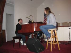
With my extra day in Delaware (so I was right on the border with Delaware and Maryland, but we were closer to Newark, Delaware), my CS host and I had a lot of fun. Despite the weather, we ventured out with his friend to a farmer’s market. Then they put on a private concert for me at the church he plays organ at (he and his friend are a vocal/piano duo). Finally, we just vegged out all day watching NetFlix. It felt good to just sit around (not on a bike) all day and relax.


The next day I woke up and set off at about 8am. 70 miles was going to be a big day for me. Everything looked easy except for crossing the Susquehana. There were three possible crossings: Route 40, I-95, and Route 1. Bicycles were only allowed on Route 1. However, Route 1 was over the Conowingo Dam, a one-mile two lane road that looked treacherous from Internet pictures. It was the only option though. I didn’t quite know how I would cross it. I figured I would just do it or if it was too bad, try and hitchhike across it in a passing pick-up truck. I had been riding for a couple hours when I knew the dam should be nearby. I was still planning on stopping at the edge to re-assess the situation. However, then there was a giant hill, then a curve, then the dam was at the end of the curvy hill. There was no time or place to stop, and the hill shot me off across the dam at about 20 miles an hour. It felt surprisingly safe. Although it was two lanes, the lanes were wider than they appeared. And traffic was sparse enough that passing cars could do so with no problem. After a few minutes, I was across the bridge. Only Baltimore awaited.


The rest of the ride was pleasant and rather unmemorable. It was a beautiful day, but I’ve had so many of those by now that they mostly blur together. Baltimore itself seemed like a rather nice city. The Ravens decorations were very noticeable and appreciated; I like a city that supports its teams. The downtown area was rather hilly but very scenic. It seemed like it wouldn’t be a bad place to live.

They were losing to the Cardinals but had a great comeback

I found my host’s place with no problem, and we parked my bike in the backyard. She and her hilarious French roommate prepared a fantastic dinner, and afterwards, we talked about aid and development for a long time. My host was also interested in international development, so I thought it was great that I had a chance to meet her. Before going to bed, I tried planning my route to DC. It didn’t look good for me.